เกาะญอง์วี
ညောင်ဝီးကျွန်း

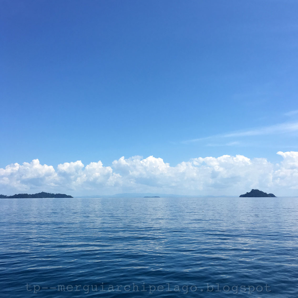
Leaving the 115 island (on the right) behind, if looking eastwards, we can see a row of islands in different size from north to south.
The big Nyaung Wee Island (Buda Island in Google Maps) is in the middle. There are both Moken and non-Moken people on this island, their village and temple are on the east.
The next medium-size one on the left is Bo Net Kyaw Island (ဗိုလ်နက်ကျော်, Pulo Balu in Wikimapia), then two small islands, Bagan Pyar (ပုဂံပြား, Pulo Hayat in Wikimapia) which I'd like to translate as Dish Island and Nga Mok (ငါးမုတ်) or Pomfret Island. On the left end, there are many overlapping islands, Gu Gyi (ဂူကြီး) or Big Cave Island, Linn Shu (လင်းရှူး, Pulo Labiaung in Wikimapia) or Dolphin Island, Bo Cho (ဗိုလ်ချို) Island and the last one at the north end, Lampi or Kyunn Tann Shey (လန်ပိ, ကျွန်းတန်းရှည်) Island.
พอเรือพ้นเกาะ ๑๑๕ ซึ่งอยู่ขวามือสุดในรูป หากมองไปทางทิศตะวันออกจะเห็นเกาะขนาดต่างๆ ต่อเนื่องเป็นแนวจากเหนือลงใต้
เกาะญอง์วี (บูดาในแผนที่กูเกิล) เกาะใหญ่ตรงกลางรูป มีทั้งชาวเลและชาวบกอาศัย โดยมีหมู่บ้านและวัดตั้งอยู่ทางตะวันออกของเกาะ
เกาะขนาดกลางถัดไปทางซ้ายคือ เกาะโบแนะอ์จอ (ဗိုလ်နက်ကျော်, เกาะบาลูในแผนที่วิกิแมเปีย) ต่อไปเป็นเกาะเล็กๆ สองเกาะ คือ เกาะบะกาง์ปยา (ပုဂံပြား, เกาะฮายะในแผนที่วิกิแมเปีย) ซึ่งขอเรียกเป็นภาษาไทยง่ายๆ ว่าเกาะจาน กับ เกาะงาโมะอ์ (ငါးမုတ်) หรือเกาะจะละเม็ด ส่วนทางซ้ายมือสุดที่เห็นซ้อนกันอยู่ในรูป คือ เกาะกูจี (ဂူကြီး) หรือเกาะถ้ำใหญ่ เกาะลีง์ชู (လင်းရှူး, เกาะลาเบียงในแผนที่วิกิแมเปีย) หรือเกาะโลมา เกาะโบโช (ဗိုလ်ချို) และเกาะลาง์ปิหรือจูง์ตาง์เช (လန်ပိ၊ကျွန်းတန်းရှည်) ที่อยู่ทางเหนือสุด

2016-11-15 11:17
In this picture, Bo Net Kyaw Island is in the middle. The nearby smaller Dish and Pomfret Islands can still be seen separately on the left.
These names remind me a folk tale of their neighboring islands in the Gulf of Thailand just across the narrow Kra Isthmus, the tragic story of Ta (Grandpa) Mong Lai, Yai (Grandma) Rampung and their daughter, Yom Doei. The legend which makes the islands come alive.
I ask the crew "Any similar folk tale around here ?" The response is "not sure"
รูปนี้ เกาะโบแนะอ์จออยู่ตรงกลาง เกาะจานกับเกาะจะละเม็ดที่อยู่ทางซ้ายใกล้ๆ ยังเห็นแยกกัน
ได้ยินชื่อเกาะพวกนี้แล้ว ทำให้ผมนึกถึงนิทานพื้นบ้าน ตำนานของเกาะใกล้ๆ กัน แต่อยู่ในอ่าวไทย อีกฟากหนึ่งของคอคอดกระ คาบสมุทรแคบๆ ตรงนี้ เรื่องราวโศกนาฏกรรมของตาม่องล่าย ยายรำพึง และยมโดยลูกสาว อันเป็นที่มาของชื่อเกาะจำนวนมากในบริเวณนั้น การผูกเรื่องที่ทำให้เกาะต่างๆ มีชีวิตชีวามากขึ้น
ผมสอบถามลูกเรือว่า มีเรื่องพื้นบ้านเกี่ยวกับที่มาของชื่อเกาะพวกนี้หรือเปล่า ได้รับคำตอบว่า ไม่แน่ใจ

2016-11-15 11:39
These names remind me a folk tale of their neighboring islands in the Gulf of Thailand just across the narrow Kra Isthmus, the tragic story of Ta (Grandpa) Mong Lai, Yai (Grandma) Rampung and their daughter, Yom Doei. The legend which makes the islands come alive.
I ask the crew "Any similar folk tale around here ?" The response is "not sure"
รูปนี้ เกาะโบแนะอ์จออยู่ตรงกลาง เกาะจานกับเกาะจะละเม็ดที่อยู่ทางซ้ายใกล้ๆ ยังเห็นแยกกัน
ได้ยินชื่อเกาะพวกนี้แล้ว ทำให้ผมนึกถึงนิทานพื้นบ้าน ตำนานของเกาะใกล้ๆ กัน แต่อยู่ในอ่าวไทย อีกฟากหนึ่งของคอคอดกระ คาบสมุทรแคบๆ ตรงนี้ เรื่องราวโศกนาฏกรรมของตาม่องล่าย ยายรำพึง และยมโดยลูกสาว อันเป็นที่มาของชื่อเกาะจำนวนมากในบริเวณนั้น การผูกเรื่องที่ทำให้เกาะต่างๆ มีชีวิตชีวามากขึ้น
ผมสอบถามลูกเรือว่า มีเรื่องพื้นบ้านเกี่ยวกับที่มาของชื่อเกาะพวกนี้หรือเปล่า ได้รับคำตอบว่า ไม่แน่ใจ
2016-11-15 11:39
At some point, the mainland can be clearly seen in the background. In fact, the islands around here are not just in the same range themselves, but also continually connect with the nearby mainland.
A small flat island in the middle of this picture is Than Dar Net Island. It is in the inner range near the continent with the names in group called Than Dar Phyu (သန္တာဖြူ), Than Dar Nee (သန္တာနီ) and Than Dar Net (သန္တာနက်) which mean white, red and black coral respectively.
The foreground island on the left is Big Cave Island. On the right, The 'Pomfret' does overlap the 'Dish' Island.
'The Fish is now ready on a Dish' I feel hungry, time for lunch!
ช่วงหนึ่ง เราจะมองเห็นผืนแผ่นดินใหญ่ที่อยู่ไม่ไกลเป็นฉากหลังชัดเจน ความจริงหมู่เกาะบริเวณนี้ไม่เพียงต่อเนื่องเป็นแนวเดียวกันเอง แต่ยังเชื่อมต่อเป็นผืนเดียวกับแผ่นดินใหญ่ที่อยู่ใกล้ๆ นี้อีกด้วย
เกาะเล็กๆ ราบๆ ตรงกลางรูป คือ เกาะตาง์ดาแนะอ์ ซึ่งอยู่ในแนวเกาะที่ต่อเนื่องกันด้านในใกล้แผ่นดินใหญ่ มีชื่อเป็นกลุ่มจากเหนือมาใต้ คือ ตาง์ดาพยู (သန္တာဖြူ) ตาง์ดานี (သန္တာနီ) และตาง์ดาแนะอ์ (သန္တာနက်) หรือปะการังขาว แดง และดำ ตามลำดับ
เกาะที่มองเห็นอยู่ด้านหน้า ซ้ายมือคือเกาะถ้ำใหญ่ ส่วนขวามือ คือเกาะปลาจะละเม็ดที่ตอนนี้ซ้อนอยู่กับเกาะจานแล้ว
ปลาอยู่ในจานเรียบร้อยแล้ว จะละเม็ดเสียด้วย ท้องผมจึงเริ่มหิว ได้เวลาอาหารเที่ยวพอดี
No comments:
Post a Comment